
Uttarkashi Disaster Strikes Notified Eco-Sensitive Zone; Experts Cite Ongoing Floodplain Violations
SHARE
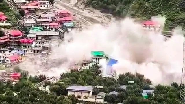
The devastating flash flood and debris avalanche in Dharali, located in the Uttarkashi district of Uttarakhand, took place within the ecologically fragile Bhagirathi Eco-Sensitive Zone (ESZ). Over 60 people have been reported missing as rescue operations continue for a second day. Experts believe that unregulated development, particularly construction along river floodplains, has intensified the disaster’s impact.
The Bhagirathi ESZ, spanning 4,157 sq km between Gangotri and Uttarkashi, was notified in 2012 to preserve the ecology of the Ganga river near its source. The Bhagirathi river, a primary tributary of the Ganga, merges with the Alaknanda at Devprayag to form the Ganga proper. The ESZ designation is intended to safeguard the region from harmful development, but several violations have occurred, undermining its protections.
A major concern is the Char Dham all-weather highway project, a central government initiative that cuts through this sensitive zone. Despite environmental challenges and legal opposition, the Supreme Court eventually cleared the project. Activists and ESZ monitoring committee members have repeatedly raised alarms about unregulated activities in the region. Mallika Bhanot, a committee member from the NGO Ganga Ahvaan, stated that this was a natural event worsened by human activity. She pointed to unchecked construction near river tributaries, including helipads in Jhala and multi-storey hotels near Maneri and Jamak along the Ganga's banks, which violate ESZ norms and compromise regional safety.
The Char Dham project itself has seen controversial elements, particularly the stance of the Border Roads Organisation (BRO) that road widening along the Gangotri stretch does not need an Environmental Impact Assessment (EIA). ESZ committee members have strongly opposed this view, especially in the wake of the Silkyara tunnel incident in 2023, emphasizing the importance of adhering to environmental regulations.
The exact cause of the Dharali disaster remains unclear. However, experts suspect it was triggered by heavy rainfall in a landslide-prone area. A bulletin from the Central Water Commission’s Himalayan Ganga Division identified three flood-affected zones: Dharali, an area near Sukhi top, and another near the Harshil Army camp. The India Meteorological Department (IMD) reported no extreme rainfall in the region on the day of the disaster, with a maximum of 43 mm rainfall recorded in Sankri, suggesting the possibility of a cloudburst or a glacial lake outburst as triggers.
Dipali Jindal, a senior consultant with the National Disaster Management Authority, noted that videos showed what appeared to be a mudslide, a type of landslide involving fast-moving debris. She suggested that prolonged rainfall may have saturated the soil, reducing internal cohesion and destabilizing slopes. IMD Chief Mrutyunjay Mohapatra added that persistent rainfall across Uttarakhand and nearby states in recent days could also contribute to such events, even without a single extreme rainfall incident.
In summary, the Uttarkashi disaster is a grim reminder of the dangers of unregulated development in ecologically sensitive zones, compounded by natural hazards like landslides and flash floods, and highlights the urgent need for strict enforcement of environmental protections.